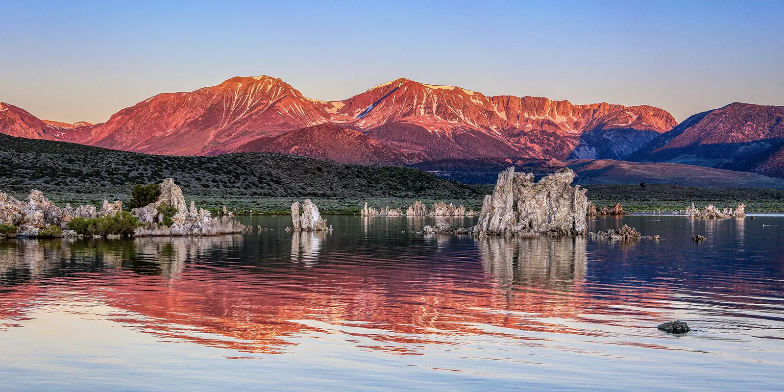
Tufa towers characterize Mono Lake, which sits at the edge of the California/Nevada border. Tufa towers are Mono Lake’s iconic calcium carbonate (limestone) structures that rise up from underwater. It is one of the oldest lakes in North America, at over one million years old.
Mono Lake sits within the Mono Lake Tufa State Natural Reserve and is an endorheic lake, which means it has no outlet. Historically, runoff from the Eastern Sierra streams has fed Mono Lake. This runoff was greatly reduced in the 1940s. Water only leaves the Mono Basin by evaporation.
Mark Twain referenced Mono Lake like this, “Its sluggish waters are so strong with alkali that if you only dip the most hopelessly soiled garment into them once or twice, and wring it out, it will be found as clean as if it had been through the ablest of washerwomen’s hands.”
US 395 hugs Mono Lake on the west, SR 167 flanks its northern edge, and SR 120 zigzags along its southern border. Its water is hypersaline, hyperalkaline, and saltier than ocean water. Sudden winds amplify quickly on Mono Lake, which makes it dangerous to venture far from its shore at times.
What Is Special About Mono Lake?
If you are a first-time visitor to Mono Lake, the Mono Basin National Forest Scenic Area Visitor Center is the place to start. Find the visitor center 1/4-mile north of Lee Vining, just east of US 395. The Visitor Center features exhibits, films, and information about the natural and human history of the Mono Basin.
Visitors can easily reach the South Tufa Area, with astounding views of the tufa towers and a one-mile, self-guided nature trail. South Tufa is a federal fee area and accepts national interagency passes. The Old Marina, one mile north of Lee Vining, also off of 395, offers wonderful bird watching opportunities.
A 1/2-mile trail connects the Old Marina to the visitor center, and there are small tufa areas offshore. Naturalists lead walks May through October at South Tufa and other notable places around Mono Lake. Visitors can check schedules at the visitor center.
Crater Trails
Then, hop over to the Panum Crater, the youngest crater of the Mono crater chain. The Panum Crater Trail leads to the cone and rim of the crater. This crater is a rhyolitic plug-dome volcano and has a steep-sided, rounded mound. Rhyolite lava is lighter in color and weight than basalt lava, stiffly dense, and slow-flowing.
When you visit the north shore area, near the Mono Lake County Park, take a walk on the State Natural Reserve Boardwalk to access the Reserve wetlands on the lakeshore. This is an excellent bird watching spot. Mono Lake provides habitat and support for approximately 100 bird species, including ducks, geese, grebes, gulls, and shorebirds.

On The Water
Canoeing, kayaking, and hiking provide striking views of tufa structures, wildlife, and the surrounding hills and mountains. Visitors paddling Mono Lake need to take caution of sudden high winds and stay closer to the shore. There are picnic tables at Mono Lake County Park.
You cannot camp at Mono Lake or in the Natural Reserve. However, dispersed camping is allowed in limited locations of the Scenic Area above the elevation of 6,417 feet. There are about nine campgrounds just west of US 395 on the eastern edge of Mono Lake. Yosemite National Park lies to the east in the Central Sierra Mountains.
Approximately 70 species of migratory birds feed on a trillion brine shrimp and millions of alkali flies at Mono Lake, which include one million eared grebes, 50,000 California gulls, thousands of killdeer, and Wilson’s and red-necked phalaropes.
Is Mono Lake Worth Seeing?
Mono Lake is set in an arid, high desert basin bordered by the Sierra Nevada mountains to the west and the volcanic Mono Craters to the south. Mono Lake’s surrounding landscape features sagebrush, dry grasslands, and scattered juniper and pinyon pine trees. The area sports a stark, rugged beauty with expansive views.
You Bet! Mono Lake saw 4.2 million visitors in 2018. In 2019, the Economic Development Department of Mono County reported that 48% of visitors were Californians, 28% from the U.S., and 24% hailed from other countries. Return visitors accounted for 62%, and had made an average of three trips to Mono Lake.
Is Mono Lake Safe to Swim In?
Yes. And No. The salt content in Mono Lake is 2.5% higher than in the ocean with an alkaline content of pH 9.8. You can float without treading water in hypersaline water bodies. If the water pH is higher than 8, swimmers risk developing skin rashes.
The Natural Reserve recommends keeping the water out of eyes or cuts, as it will sting. Keep your swim time to 20 minutes and carry fresh water to rinse off after swimming. Bathers have reported on Mono Lake’s curative effects for years.
What Happened With Mono Lake?
Mono Lake is endorheic with no outlet and the only way water escapes is by evaporation. This lake depends on runoff from the eastern slopes of the Central Sierra Mountains. In the early 1940s, the Los Angeles Aqueduct System diverted part of the natural runoff from the mountains.
By 1990, inadequate flow from runoff into Mono Lake had resulted in the loss of half of Mono Lake’s water, an ecological disaster. Airborne alkaline dust created a severe health hazard. Conservation organizations activated, and the California State Water Resources Control Board issued orders to protect the Mono Lake Basin in 1994.
Is Mono Lake Filling up Again?
Mono Lake’s water level has consistently risen since 1994, and there is a target level that may be reached before 2030. Even so, experts predict that Mono Lake’s water level will not return to pre-diversion levels. On the upside, its lower water level exposed more of the iconic and photogenic tufa structures that define Mono Lake.


